Welcome to the third issue of the Dialogue’s newsletter. We are happy to include a draft agenda for the Dialogue’s 27th Annual Meeting in January 2021. You will receive an email with more information and registration information soon.
Our lead article explores what farmers and ranchers are doing to build resilience in a part of the state with little surface water. It is one more story about good information being essential to good water management.
Contents
- Navigating to Long-Term Ecological Health: Groundwater, Soils and Healthy Landscapes by Kate Zeigler
- New Mexico Water Dialogue 27th Annual Meeting Draft Agenda
- Panel: Resilient Water Management in Practice Science Leads the Way: An Arizona Experience – Holly Richter by Kathy Grassel
- Panel: Resilient Water Management in Practice Acequias on the Vanguard of Resiliency – Paula Garcia by Kathy Grassel
- Panel: Resilient Water Management in Practice Thinking Resilience in the Lower Rio Grande – Phil King by Kathy Grassel
Navigating to Long-Term Ecological Health: Groundwater, Soils and Healthy Landscapes
By Kate Zeigler, Ph.D., CPG
Zeigler Geologic Consulting, LLC
(This article is a longer version of a blog post submitted to the New Mexico Healthy Soil Working Group*.)
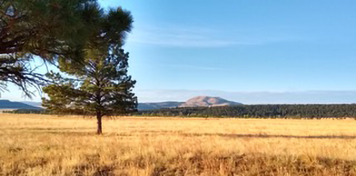
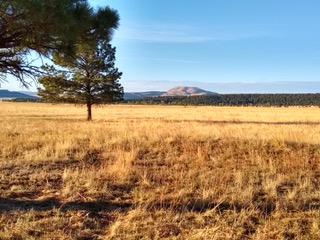
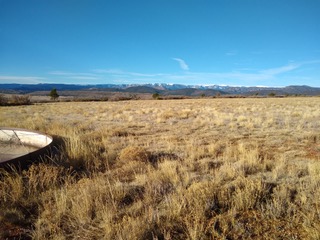
In northeastern New Mexico, we don’t get many tourists who stop by to look at the scenery … and in part, that’s because we don’t have much to look at if you’re a tourist. And a big photo op for folks passing through is live water. Which we ain’t got much of. So, when we think about the vast open spaces of the High Plains, how do our agricultural producers make a living out here? Because there is so little surface water, farming and ranching rely primarily on groundwater resources and we are at the mercy of increasingly unpredictable weather patterns. An oft-forgotten corner of the American Southwest, this little patch of New Mexico didn’t have much data at hand to understand how groundwater resources worked until the Northeastern Soil & Water Conservation District formed an alliance with a consulting geologist. The producers knew very little about geohydrology and the geologist knew nothing about crop types or which type of cow was chewing on her car’s back bumper. But from this sprang a regional effort to gather data on the groundwater resources and figure out how to manage every precious drop better.
Effectively, what we know now that we didn’t know then is that the aquifer systems beneath the High Plains are way more complicated than we might have anticipated. Two wells a half mile apart may very well not be drawing from the same pool of groundwater (so please don’t shoot your neighbor for “stealing” your well water). Lateral changes in thickness, variations in rock types, ancient topography filled in with yet other deposits, volcanoes, and many other geologic phenomena have created a series of “bathtubs”. And so the word to the wise in northeast New Mexico is to manage each well as its own resource and assume it’s probably not recharging in your life time. Take care of the groundwater and the groundwater will take care of you.
As this effort to understand groundwater resources has built, so have parallel efforts to understand the soils of the region, which are so critical to successful agricultural operations. Both efforts are far behind where they need to be – the world, the weather, the economics, all are changing so much faster than we can gather and analyze data. But the effort must be made. When we think about where water goes on and under the land, we all know our basic hydrologic cycle: rain and snow fall on the land and some swiftly flows away as sheetflow or along our drainages. Some water ponds in low spots and some sinks quickly down into the ground. Evaporation and evapotranspiration mobilize some of that precious moisture back up into the atmosphere and off we go again! But … what’s happening to that water that left us when it sank below the surface? As any homeowner knows, one of the most maddening fix-it jobs is plumbing. Why? Because water goes where pressure, gravity, porosity, permeability, etc. guide it. Not where you want it to go (e.g., down the drain, please, and not all over the floor).
Where moisture is not pooling on exposed bedrock, soil is the interface that the moisture moves through in its subterranean voyage. Soil scientists understand this realm very well in terms of soil texture, chemistry, interaction with plants, etc. But as many of us are beginning to realize, we do not always understand the intricacies of how water moves through soil. So, are our soils helping get water down to replenish aquifers? Is that water traveling sideways until it escapes into perennial pools and streams, springs and seeps? Is it evaporating after all? Sucked up by thirsty plants and released as evapotranspiration? These are all huge questions that will take an army of minds to figure out and as with all parts of the natural world, it’s complicated!
Back in the 18th and 19th centuries, scientists studied many different aspects of the world, wandered about being “naturalists”, and weren’t really pigeon-holed into discrete disciplines. The diving down myriad rabbit holes, the splitting of science into each discipline, and then the sub-splitting of those disciplines has led us to many fascinating observations and discoveries of how the world works – we’re getting good at the nuts and bolts! But now, it’s time to pull all those nuts and bolts back together again. Collaborative multidisciplinary work is really all the rage these days and it needs to be. And now we need to bring our efforts to bear on the soils – that critical interface in which so much happens that we depend so much upon. Whatever your preference for food type, be you herbivore, carnivore or omnivore, your food comes from that most important and most delicate layer of dirt.
How will understanding and influencing soil health help with water cycling? Soil scientists will be the first to tell you that a healthy soil not only produces better forage, but it retains water better. And as more vegetation grows on a healthy soil, erosion is slowed down. Sheetwash is buffered by all the plant stalks and stems, and rushing water slows and has a chance to percolate downwards. This water may never make its way all the way down to the local aquifer – many aquifers in the region are isolated from the world above by bedrock shale layers that prevent (or greatly slow down) the downward migration of precipitation to the water table. But, more water held in the soil can potentially revive seeps and springs, and fatten up those perennial pools that occur in our rocky little creeks. There is little to lose by learning about our soils and then learning how to help them. And as we all grapple with longer and longer droughts, remember the horrible feedback loops that develop. As plants die off, bare ground expands. Our rains now seem to come in short, high-intensity events that cause significant erosion so quickly that it’s painful to see. That water runs off the land so fast that it can’t percolate down, and soil moisture and unconfined aquifers suffer as a consequence.
Soil health is critical, no doubt! But there are trade-offs, as with all things in life. The short-term economics of the tasks needed to heal a soil can seem overwhelming. Every operation needs to sit with these ideas and determine the short-term economic pain of paying for things that will help the soil recover versus the long-term payback of a healthy, functional ecology. And no two operations will tackle this balance the same way. Every ranch, every farm is unique. Some operations have many different soil types, some have only a few. And so broad-brush “fix-its” should always be tweaked to fit the operation – never give up on the old creative use of baling wire and duct tape approach! Phone apps such as LandPKS, GrasSnap, Microbiometer, etc. can be very useful for quick analysis of the state of the land. Established photo points can help you understand change over time in different pastures or on different crops. Remember the importance of ground cover, be it litter or living plants, to help with cooling the surface and minimizing evaporation. Use exclosures to see what happens when you don’t let the cattle graze an area for a while – what pops up? Manage your groundwater. Learn which of your wells may be able to recharge in good years. Rely on your non-recharging wells in bad years – treat them like a noninterest-bearing savings account. Consider infrastructure – rotational grazing techniques move the cattle to help the land, so move your water too! Storage tanks and pipeline systems are expensive in the short term, but can pay off enormously in the long run.
One final note: for too long, scientists have nerded their way along, noses pressed to the plant, the dirt, the rock. For too long, agricultural producers have done their best to take care of their land using methods that made sense at the time. It’s time for producer and scientist to saddle up together (and it’s gonna be a long ride …). One of the greatest joys this scientist has taken from being a free-range geologist running loose on the High Plains is what she’s learned about farming and ranching and seeing how the knowledge she has can fit into the knowledge her partner landowners have. Landowners are the stewards – they know the land better than any scientist ever will. But the combined work of both can catapult us much further in our work to heal this land. And let us take care of the land, so the land can take care of us.
*To learn more about the NM Healthy Soil Working Group, watch informative webinars, and read interesting blogs, please visit: https://www.nmhealthysoil.org/
SAVE THE DATE
New Mexico Water Dialogue 27th Annual Meeting
“The Next 50 Years: Envisioning New Mexico’s Water Future”
January 13 and 14, 2021
Zoom Meeting
DRAFT AGENDA
| January 13, 2021 | |
|---|---|
| 9:00-9:15 | Welcome and Introductions – Jason John, President, New Mexico Water Dialogue |
| 9:15 – 9:30 | Welcome from Governor (not yet confirmed) |
| 9:30-10:00 | Keynote –Eric Perramond, Professor of Environmental Science and Southwest Studies at Colorado College: “Unsettled Waters in an Unsettling Climate: Learning from New Mexico” |
| 10:00 – 10:15 | Break |
| 10:15 – 11:45 | Panel Discussion: Written in Water and Sand: What the Drying of the Rio Grande Means to Our Communities Moderator: Laura Paskus, Producer of New Mexico In Focus‘s series “Our Land: New Mexico’s Environmental Past, Present, and Future.” |
| January 14, 2021 | |
|---|---|
| 9:00 – 9:15 | Welcome – Aaron Chavez, Vice President, New Mexico Water Dialogue |
| 9:15 – 10:00 | Keynote: Rolf Schmidt-Petersen, Interstate Stream Commission Director: “Addressing New Mexico’s Water Reliance in the Face of Continued Drought and Increasing Temperatures?” |
| 10:00 -11:45 | Panel Discussion: Water Tradeoffs Among Agriculture, Municipalities, and the Environment On New Mexico’s Rio Grande Moderator: John Fleck, Professor, NM Water Resources Program, UNM |
| 11:45 – 1:15 | Break |
| 1:15 – 1:30 | Introductions to Table Talks – Eileen Dodds, Secretary/Treasurer, New Mexico Water Dialogue |
| 1:30 – 3:00 | Table Talks (Topics under development) |
| 3:15 | Adjournment |
Panel: Resilient Water Management in Practice
Science Leads the Way: An Arizona Experience – Holly Richter
by Kathy Grassel
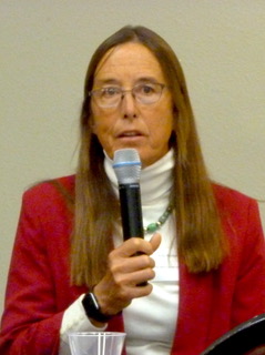
The Nature Conservancy
Arizona has a lot in common with New Mexico demographically, hydrologically, socially, and environmentally so it makes good sense that the Dialogue brought Holly Richter to present an Arizona experience to pair with our own and give New Mexicans some insights perhaps not considered until now. Holly Richter is the Arizona Water Projects Director for The Nature Conservancy with background in riparian ecology and hydrology. For the last 20 years she’s been working on issues on the San Pedro River. The Upper San Pedro watershed flows out of Mexico; its headwaters are in Sonora. It flows north into Arizona. Sharing this watershed is the BLM’s National Riparian Conservation Area, the U.S. Army’s Fort Huachuca, the cities of Bisbee, Sierra Vista, and Tombstone, many rural residents in Cochise County, and others. The area has very limited surface water supplies and is heavily reliant on groundwater. “Groundwater as you know is the invisible crisis that we can’t see and seldom think about compared to surface water,” Richter says. Things were bad enough with so many disputes, litigation, “dueling hydrologists,” and animosities that finally people agreed to collaborate and develop one groundwater model to be built with assistance from USGS.
The model showed numerous cones of depression where the groundwater levels had declined, cones that likely started in 1940 when the first gallon was pumped in the valley. “The projections of the model over time told us that we could anticipate those cones growing and spreading,” she says. “The thing is that as the groundwater depletion occurs, a flowing river and a riparian corridor might not feel those impacts for many decades. So there’s this lag response, this invisible killer coming towards your river.” What Richter and her colleagues had to figure out back in 2000 was “how to become resilient to a crisis that’s already occurred but hasn’t happened yet.”
A total of 21 members made up the partnership—local, state government agencies, the public/private sector, non-profits, and business. Everyone was at the table. They came up with a framework to work toward sustainable yields for groundwater. “What we learned was that you have to incorporate the social, the economic, and environmental needs of water, and those players better all be at the table,” she says. “You need to create the criteria to how you can be successful in those three realms in terms of water, and then solve the problem.”
Okay, what does it really mean—social and economic factors? Richter said that for their community it meant they wanted local participation in water management. They didn’t want the feds to come down and tell them what to do. BLM had a federal reserved water rights claim for Huachuca. They wanted to make it a local decision-making process. Huachuca wanted to be able to accept new missions–important to them and to the whole economy of the area. Bottom line, according to Richter, is that social and economic factors can actually be quantified in terms of water, and you have to do it in order to create collaborative agreements. “What that means is that you’re not going to get it all, so be specific on what you need the most for environmental flows, what you need the most for your cultural and social needs, and exactly when you need it, and where you need it,” she says.
In creating a water budget–the bones of the model-–they discovered demand reduction measures that they could take. “We started in 2000 with 12,000 acre-feet demand, projected to grow to 14,000 by 2012, and instead we cut it in half,” she says. “These are the things that started to come out of a collaborative that was really intended to just agree on the science. Pretty soon if you start to agree on the science, you actually start to reach the same conclusions about what things can be done to fix some of the problem.”
How do you be resilient for things that happened a decade ago? The groundwater model indicated that to cease all pumping, the region was still in big trouble, so to meet long-term water needs, a regional network of eight aquifer recharge projects was initiated in specific locations along 25 miles of the river. Of the 21-member agency group, the cities of Sierra Vista and Bisbee, Cochise County, the Hereford Natural Resource Conservation District, and the Nature Conservancy were named as able to do the projects with demand reduction measures in place that would move the region to sustainable yield.
One fortuitous thing that happened was when three planned subdivisions along the San Pedro went into bankruptcy when the real estate market crashed. Fort Huachuca stepped up and helped buy them through one of its army programs. “We bought those as a consortium and flipped them over to Cochise County to manage its aquifer recharge projects,” Richter says. “None of that could have happened without the personal relationships that took years and years to develop, with decision makers understanding the tradeoffs and how this move could benefit the entire region over the long term.”
Another win-win project with multiple benefits coming out of this consortium is a sediment reduction project that also serves as a stormwater recharge facility funded by Arizona Department of Environmental Quality. It began with a rancher with a big headward erosion issue on his ranch partnering with groups that could fund it. “These are expensive projects, but because of the multiple benefits and because we thought across these lines of water quality and quantity, stormwater, groundwater, we could make a case and come up with the money to do the project.”
Richter concludes that despite a likely consistent sizable cone of depression in the aquifer, groundwater can be still managed in a way that it sustains flow through the river and alluvial aquifer. “It’s dicey ground because we have not solved the original problem, but we hope it will buy us many decades to do what it’s going to take to solve that bigger problem. I can’t emphasize enough how useful that groundwater model has been in making those kinds of decisions. It’s been an interesting journey. You think, oh if we could just get a model, and then you think, gosh, if we could just reduce our demand, and then just build out these eight projects…” A journey without end? Is the end of the road just the beginning? Richter says yes.
Panel: Resilient Water Management in Practice
Acequias on the Vanguard of Resiliency – Paula Garcia
by Kathy Grassel
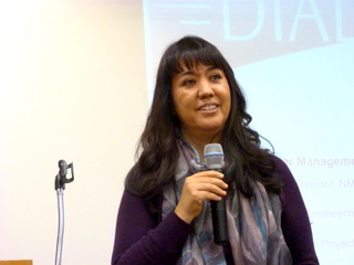
New Mexico Acequia Association
The robust acequia communities that characterize New Mexico culture embody an obvious paradigm of resilience that Paul Garcia has brought to our attention over and over. Garcia is the Executive Director of the New Mexico Acequia Association whose decades-long work has been largely with people working on the land–farmers and ranchers, acequia officers, commissioners, and majordomos. She’s been an acequia commissioner herself, so has also worked with mutual domestics, water district officers, and supervisors of the different districts around the state. Garcia comes from Mora in northern New Mexico. “The way we allocate water is mostly by looking up at the snowpack and figuring out how much we think there’ll be because of the snowpack,” she says. “It’s very low tech, but it’s a tried and true way of sharing water.”
One would have thought that this low-tech method of water allocation would have long ago been steamrolled by “modern” statutory forces, but no, and there’s a reason for that, according to Garcia. It’s querencia—that place from where one’s strength of character is drawn, the love of place where the relationship between the place and its people is bound up together as one. Inferred in this querencia is that any threat to that relationship is going to be met with resistance. “There was increasing pressure at the end of the 20th century to transfer water out of acequias due to growth,” Garcia says. “That came about because of the way New Mexico law treats water as a commodity with the 1907 water code and appropriation doctrine, and the severability of state-based water rights from the land. But if enough water transfers occurred in any one acequia that acequia would have problems with viability.” Querencia versus market forces was a classic David and Goliath encounter. David won, but it took effort and years. “The communities mobilized. Over the course of the last two decades, we’ve changed the laws. We were not going to be hapless victims of market forces,” Garcia says. “We’re going to protect water as a community resource within the legal framework.”
Now included in state statute is Subsection E of Article 2 that recognizes and strengthens the integrity of the traditional acequia system, codifying in part that no individual can sever and transfer his portion without consent of the acequia commissioners. “A thing we say is, ‘If you’re not at the table, you’re on the menu,’” Garcia says. “It’s not enough to give public comment. Sometimes you need to change the policy to have a decision at the table. There are layers and layers of challenges that still face us, but getting that one power was a game-changer for acequias and gave us a fighting chance to make sure that acequias would have a say in their future and have a measure of self-determination.”
In the course of her years working with folks on a day-to-day basis getting water on the field, Garcia has many stories to tell of a caring community. She tells of a combat veteran just come home. He took over for his dad, and it turned out that their well was malfunctioning and they needed to drill a deeper well. They came to the county commission asking for help. Instead of lecturing him how he should have planned better, the action was to give him $10,000 to drill a deeper well. “I see people doing their best out of a deep sense of love for their community, taking care of their watershed, talking care of their people, making sure they have drinking water, and for acequias, making sure they have rotation water,” Garcia says. She relates another example of another acequia community coming together to oppose a new Sonic in Espanola because they were afraid the oil was going to run into their ditch. “The organic growers down the road came out in force to a planning and zoning meeting, and they killed that thing,” Garcia says. “It took a few months, but they were so mad about this Sonic. The applicant withdrew only because the people had gained some political traction. To me that’s the democratic process. People had information, they mobilized and the policy makers responded accordingly.”
Garcia says that acequia customs will most definitely be challenged by climate change and drought conditions, that water sharing needs are going to affect decision-making. “Climate change is happening, so even when we have a robust custom, we’re having to adjust those customs based on changing weather patterns,” she says. Garcia also recognizes the important role of data in these times. “For an example, in the Rio Chama, it’s not enough to go look at the water and say how 14 acequias are going to split that. It’s not easy because there are layers of governance and policy overlaid on that water. The acequias have relied on the OSE and ISC staff and expertise to provide data about how you allocate water,” she says. “There are still the principals and values of sharing but also the technical expertise needed, such as metering data, flow rates and how they’re changing from week to week.”
Garcia views the human side of resiliency as meaning values are important, democratic institutions are important, and grassroots leadership is important. “There are some hopeful signs of resiliency already happening. We’re going to tough it out. We’re not going anywhere. We’re going to bounce back. As changes come, we’re going to roll with the changes and get stronger, and stay here.” That’s querencia— the love of place.
Panel: Resilient Water Management in Practice
Thinking Resilience in the Lower Rio Grande – Phil King
by Kathy Grassel
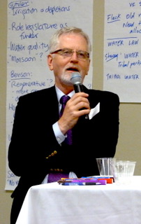
New Mexico State University
If anyone ever thought there was a once-size-fits-all to apply to agriculture in New Mexico, contrast northern New Mexico’s acequia complex where water is a community resource with the Lower Rio Grande where water is a commodity. With one of the most diverse agricultures of anywhere in the world, it would be a foolish undertaking to apply resilience measures without regard to place. That’s the word from Phil King whose lifelong career in water systems has taken him all over the state besides in the Lower Rio Grande. Dr. King is a professor and associate department head in Civil Engineering at NMSU, and also a consultant to Elephant Butte Irrigation District. He goes to the Merriam-Webster dictionary for his definition of resilient: capable of withstanding shock without permanent deformation or rupture. King would expand this definition to include adaptation to permanent deformation and rupture, because “as Dave Gutzler pointed out today, that’s where we’re headed.” A second is tending to recover from, or adjust easily, to misfortune or change. King would scratch the word “easily” in this context. “We are adapting to things because things got bad enough,” he says. “Looking at climate change, eventually people will mobilize when things get bad enough. The only question is how bad is bad enough, and I’m thinking it’s pretty bad.” He jokes he’s not quite as cheerful in all this as Dave Gutzler. He cites the things happening in the Lower Rio Grande:
- Multidecadal drought officially starting in 2001.
- Increasingly arid climate separate from the drought cycle.
- Hydrologic effects of drought and climate change passed disproportionally downstream in a river. “The LRG now is a preview of what continuing aridification will bring upstream. Think of us as the canary in the coal mine.”
- State law adjudicating to highest year’s use. Water rights are based on your maximum year’s use that you can prove up. If everyone proved up to their maximum, you are over allocated. “All the kids can’t be above average, and that’s what we have here.”
- Adjudication– telling people in what order they will be cut off. “If you manage by cutting people off, you are deforming your system, telling farmers no more groundwater pumping. You have fundamentally altered the nature of your watershed, probably irreversibly. That’s permanent deformation.”
- Municipal and Industrial water use trending up.
- Agriculture getting more efficient with higher yields and more revenue. “Farmers have figured out how to put more of their water into crop uptake, which makes for more yield, but also increases the depletions on a per unit basis within the basin.”
King goes on to describe an observable vicious circle in the Lower Rio Grande. (1) A short surface water supply leads to reduced aquifer recharge. (2) Increased groundwater pumping by both agricultural and M&I users leads to an impaired groundwater system. (3) An impaired groundwater system leads to greater losses of surface water. (4) A greater loss of surface water leads to reduced surface water supply. And then it’s “back to (1) and away you go.”
King showed slides of the Rio Grande’s hydrologic history. The graphs showed oscillations of both surface and groundwater throughout the decades. “Back in the 40s, you have a nice happy healthy aquifer going through its seasonal oscillations, then came the drought of 50s. Then it bounced back up when things got a little wetter, then crash, bounce and crash.” There was some resilience there until the current drought. Making things worse, “we developed an appetite for water in the 80s and 90s when we had all that water coming down. When you could get three acre-feet each year every year for 24 years, it starts to feel normal,” King says. “So we had a lot of acres going into things like pecans, which use a lot of water, then the water supply drops out and farmers need to maintain the same level of irrigation.”
Phil King has ideas how to organize a resilient water management system in the LRG. One is alternative supplies, which in the LRG infers desalinization. King favors desal as a valuable part of a water portfolio, but it’s what he calls niche water–water for a high value thing like industrial development in Santa Teresa, but not for irrigation of crops. A second is surface water treatment because if M&I is using surface water, they are not using groundwater. “Unfortunately that will result in a necessity to buy and dry agricultural lands, to permanently fallow ag lands, which is bad for the long-term viability of agriculture, but it is necessary.” A third is floodwater capture to use directly, or infiltrate it to recharge the aquifer. These are all good things to pursue, according to King, but all “chump change” compared to the major shift in the surface water supply driving the whole system. King moves on to groundwater management strategies. He envisions a system of tiered status indicators to show the status of the hydrologic system. “The worse shape you’re in, the more aggressive you have to get with your responses,” he says. A practical sampling of measures he would look at include offsets of municipal and industrial pumping, buy-and-dry, rotational fallowing where land could come in to production in wet times and go out of production in drought times, and physical reduction in M&I use, and, “even dare I say it as a consultant to Elephant Butte Irrigation District, a reduction in the FDR—farm delivery requirement—that it goes down when it gets bad enough.” The FDR reduction is not intended to impair high water use crop production; it’s intended to motivate farmers to fallow ground to bring that water onto the high value water use crops. Some of these things are already in place, “but we also have internal disputes where people think everybody should have to reduce their water use … except me because I’m senior,” King jokes, repeating what he’s heard many times. “If we can’t keep up with the rate of change, things will deform and rupture. We need increasingly intelligent and creative management. We really don’t have that. We basically run water, pump water out of the ground, give it a shot of chlorine and send it on its way. Not too sophisticated in our management down there. So stay tuned, and we’ll see what happens.”